Recently, the Kingsport Times-News reported that the Sullivan County Commission deliberated acceptance of grant funding to upgrade the swinging bridge over the Holston River in Bluff City.
The article reminded me that development in a county like Sullivan, which is divided by the Holston River, has always been shaped by river crossings.
First came fords and shoals. Then came ferries. Eventually came bridges — both pedestrian and vehicular.
Communities often grew up at river crossings because that is where people, livestock, and commerce moved. When a crossing remained important, the adjoining community often grew with it. When a crossing went away, shifted, or lost its role, the nearby community could be affected, sometimes severely.
That article caused me to revisit a piece I started a couple of years ago about Pactolus and county funding debates from more than 100 years ago.
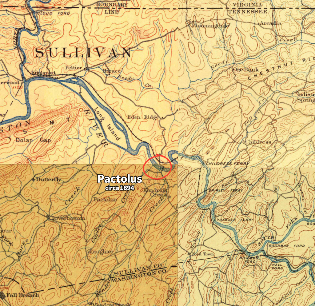
Pactolus was one of the earliest business centers on the Holston River in Sullivan County. But for a bridge relocation and road rerouting, it might have evolved into one of the county’s more prominent communities.
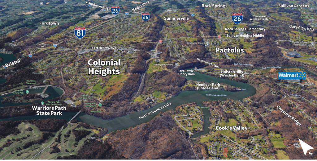
It had an ironworks, a nail factory, mills, a post office, ferry access, river traffic, and roads that fanned out to nearby farms and rural communities. But as transportation patterns changed, the center of activity shifted. The old Pactolus crossing lost its role, and later growth followed the newer corridor toward Hammond Bridge, Fort Henry Drive, and Colonial Heights.
The old Pactolus bridge controversy helps explain how river crossings shaped Kingsport, Sullivan County, and the communities along the Holston.
Before there was a road to Johnson City
It is easy to look at a modern map and assume that Fort Henry Drive has always been the main route south from Kingsport.
It has not.
For much of this story, there was no modern highway leading directly from Kingsport toward Johnson City. In fact, there was no Johnson City as we know it until the railroad arrived in 1856 and created Johnson’s Depot. Johnson City was later incorporated in 1869.
Before that, roads served older purposes. They connected farms, mills, ferries, churches, post offices, county seats, river landings, and river crossings.
They led toward interior communities such as Jonesborough, Fall Branch, Fordtown, and Blountville. They also connected to crossings with names like Childress Ferry and Shipley Ferry.
Before the TVA dams, the Holston was far less predictable than it is today. Flooding was a perpetual risk. Many settlements stayed near the river because it provided transportation and trade. But they also had to stay far enough away to avoid the worst of seasonal high water.
In that environment, a crossing was more than a convenience. It shaped how people reached mills, markets, post offices, county seats, neighboring communities, and the river itself.
That was the world in which Pactolus developed.
Pactolus before the bridge
Long before the bridge controversy, Pactolus was already a working community.
Its location helps explain why. Pactolus sat near the mouth of Kendrick’s Creek, where the creek entered the South Fork of the Holston River. It also stood at the head of a natural valley where Rock Springs and Kendrick’s Creek came together. That valley offered a practical route for early travel, farms, mills, and local roads.
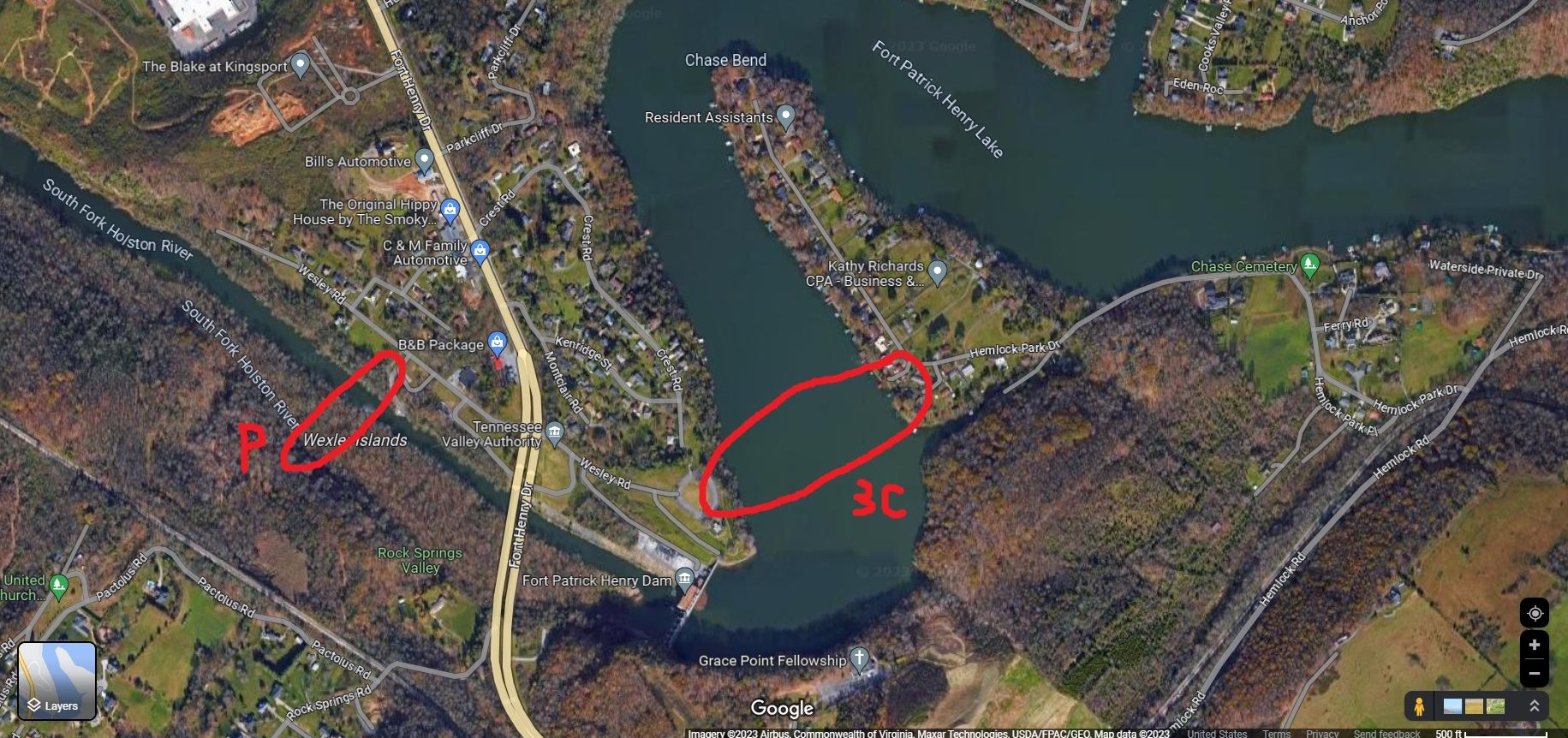
The Holston also made a tight S-curve in this area at the southern end of Chestnut Ridge. One bend was called Wexler Bend, near modern Holston Hills. The other was Chase Bend, near modern Hemlock Park. From there, the river opened toward a wide basin opposite Long Island known as Island Flats, the heart of developed Kingsport today.
The later route of Fort Henry Drive followed a different logic. It cut a tougher but more direct path through the ridge line. Pactolus belonged to the older pattern, where roads followed valleys, creeks, river crossings, and the easiest lay of the land. Fort Henry Drive belonged to the modern highway era, when engineers could force a straighter route through more difficult terrain.
By the late eighteenth century, settlers had established farms in the area. William Stacy built a grist mill and sawmill on Kendrick’s Creek. The Birdwell family later became associated with milling there as well.
Mills drew people from the surrounding countryside. Farmers came to have grain ground and lumber cut. They also exchanged goods and shared news. A mill was often one of the first anchors of a rural community.
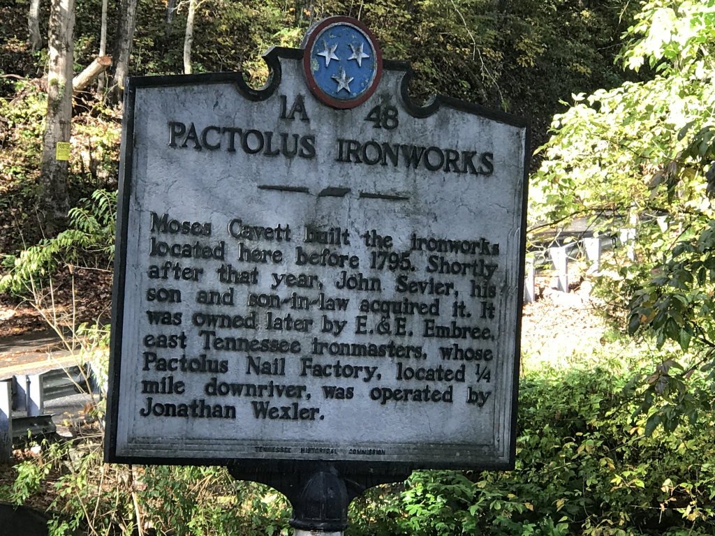
The most important enterprise was the Pactolus Iron Works, established before 1795, before Tennessee became a state in 1796. The operation passed through the hands of Moses Cavett, Walter King, John Sevier, and others. It later became associated with Elihu and Elijah Embree.
The ironworks used resources available nearby. The area had ore, timber for charcoal, limestone, water power, and river transportation. Those were the basic ingredients of early iron production. The Holston River did not simply pass by Pactolus. It helped make Pactolus useful.
A nail factory eventually operated there as well. Eastin Morris’s 1834 Tennessee Gazetteer described Pactolus as a post town on the south side of the Holston, six miles above Kingsport. Morris also noted its nail factory.
A later Kingsport Times-News article reprinted a 1916 article by Chancellor John Allison. Allison said the Pactolus nails reached markets far beyond Northeast Tennessee.
That detail shows Pactolus was not merely serving nearby farms. Its products were moving through a larger trade network tied to the Holston River and old Kingsport’s river commerce.
Pactolus also had the institutions of a small community. It had a post office, a meeting house, mills, roads, ferry access, and river access. Ferries and later bridge proposals reflected the need for a more reliable crossing.
In other words, Pactolus had many of the pieces that helped early communities grow. It had industry, transportation, water power, agriculture, mail service, and local trade.
That is worth remembering because later growth shifted toward Colonial Heights. Today, Pactolus can seem like little more than a historic name on the map. In the nineteenth century, it was a business center. Farmers, millers, ironworkers, merchants, travelers, and freight all moved through the area.
Pactolus was not unlike other Holston River communities whose fortunes were tied to crossings. Bluff City is a good comparison. It grew up around Choate’s Ford, a key river crossing for the movement of people and goods.
Pactolus had some of those same early advantages. Had transportation patterns developed differently, it might have grown into a more formal town that might have rivaled Kingsport’s prominence.
Old Kingsport and the Boat Yard
The story of Pactolus cannot be separated from the story of old Kingsport.
The original Kingsport, often called the Boat Yard, was settled in 1761 and incorporated in 1822. It was a river town long before the planned industrial city of Kingsport was incorporated in 1917.
Eastin Morris’s 1834 Tennessee Gazetteer paints a picture of that earlier community. Morris described Kingsport as a post town with stores, taverns, physicians, churches, and river commerce. It was considered the head of navigation on the Holston. Salt, iron products, flour, bacon, and other goods moved through the community by boat.
A later article by Chancellor John Allison, reprinted by the Kingsport Times-News in 1927, recalled that the Boat Yard supported a variety of trades, including blacksmiths, wagon makers, harness makers, shoemakers, and tailors. Allison also explained that the name “King’s Port” was tied to the shipping operations of William King and his salt business.
For decades, Kingsport’s economy depended on river transportation. Flatboats continued operating well into the nineteenth century.
Pactolus was part of that same river world, six miles upriver from Kingsport. Its ironworks, nail factory, mills, roads, ferries, and later bridge debates all belonged to the same larger story: how people used the Holston to move goods, reach markets, and build communities.
Early transportation links
The transportation record appears surprisingly early.
In 1829, the Knoxville Western Chronicle published a postal route connecting Pactolus and Kingsport. The route was operated weekly.
In 1831, the Rogersville Railroad Advocate carried an advertisement from Pleasant Creasy and William Dickson offering freight service by batteaux (flat boat) between Kingsport and Knoxville. Pactolus appeared as one of the destinations served by the route.
These notices show that Pactolus was already connected to broader regional trade. People, mail, and goods were moving through the area decades before the bridge controversy emerged.
The first known bridge proposal
In 1859, the Knoxville Tri-Weekly Whig and Rebel Ventilator published an advertisement seeking workers to build a bridge across the river at Pactolus.
The notice called for construction using stone piers or masonry and was signed by Rufus E. Worley and D. B. Wexler.
The advertisement does not prove the bridge was completed, but it demonstrates that local leaders wanted a fixed crossing by the eve of the Civil War.
The desire to replace ferries with a permanent structure was already present.
Floods, ferries, and local politics
An 1875 report in the Jonesborough Herald and Tribune helps explain why crossings were such an important issue.
The Jonesborough Herald and Tribune described major damage to bridges, mills, fences, and bottomland along the Holston and Kendrick’s Creek. The Birdwell mill was among the facilities damaged.
The same article also referred to turnpikes, ferries, county spending, and local political disputes. Even then, residents were arguing about where transportation money should be spent and who benefited from it.
Those arguments would return in the twentieth century.
The iron bridge at Pactolus
By 1911, an iron bridge stood at Pactolus.
The Bristol Herald Courier described it as a large iron bridge and questioned both its condition and its location. One Bristol Herald Courier item reported that a man moving cattle across the bridge became alarmed when the structure rocked under the weight.
A second 1911 Bristol Herald Courier item mocked the steep and rocky approaches. The writer suggested that many travelers preferred paying ferry tolls elsewhere rather than using the road leading to the bridge.
The criticism was not simply about the bridge itself. It was about whether the crossing actually served the public effectively.
The $15,000 bridge debate
In 1912, the bridge became part of a larger debate over county spending.
A Bristol Herald Courier writer attacked what he called an unnecessary $15,000 bridge at Pactolus, approached by a 14 percent grade.
The criticism came from the perspective of taxpayers who believed county money was being spent on roads and bridges that did not benefit them.
Others saw the issue very differently.
The Fordtown response
A 1914 Bristol Herald Courier letter from Fordtown defended the bridge.
The writer argued that moving the Pactolus bridge would effectively abandon the people living in the area. He complained that county bond money was being spent elsewhere while Pactolus residents continued paying taxes.
From the perspective of local residents, the bridge was not a luxury. It was one of the few public improvements serving their community.
The debate revealed a larger question that remains familiar today: what constitutes a local project and what constitutes a countywide benefit?
“Pactolus is right in Kingsport”
The most revealing source may be a 1918 letter written by C. L. Bachman and published in the Johnson City Staff News.
Bachman argued for improving a road connection between Kingsport and Fordtown by using portions of the old Three C railroad grade.
His most memorable observation was simple:
“Pactolus is right in Kingsport, but they have to go nine miles to get to us.”
That sentence captures the problem.
The community was geographically close to Kingsport, but poor road connections made it effectively distant. River bends, ridges, and inadequate roads created barriers that maps did not show.
Bachman was writing during the rise of the automobile age. He wanted practical roads that would connect Kingsport, Pactolus, Fordtown, and Johnson City.
The railroad changed river access at Pactolus
The railroad story adds another layer.
The old Three C railroad grade at Pactolus was on the north side of the river. That alignment followed the side of the river more naturally tied to old Kingsport and its road network. Before Fort Patrick Henry Dam and Boone Dam changed the river landscape, the Three C alignment hugged the river shore. Because of that, much of its original route is now either under Fort Patrick Henry Lake or Boone Lake.
The surviving pieces are important because they are remnants, not the full picture. Wesley Road follows part of the old grade, and another section is now part of a walking trail in Kingsport’s new Riverbend Park behind Walmart. Those traces help show where the railroad was intended to go before later dams, lakes, highways, and development changed the landscape.
But the Three C was never completed as an operating railroad through Kingsport. The operating railroad came later by a different alignment. The Carolina, Clinchfield and Ohio Railway — later known as the Clinchfield — reached Kingsport in 1909. At Pactolus, its line ran on the south side of the river, creating a new barrier between the older community and the river.
Before the operating railroad came through on the south side of the river at Pactolus, the older community had functioned as an important local business hub. The ironworks, nail factory, mills, post office, ferry access, river traffic, road connections, and nearby farms all reinforced one another.
The operating railroad changed that local landscape. People had always dealt with floods, ferries, and poor roads. But after the railroad came through on the south side of the river at Pactolus, access to the river and to older crossing routes became more complicated.
That barrier still affects the area. There is still a one-lane railroad underpass that many people use as secondary access to hundreds of homes on Pactolus Road, Rock Springs Road, and Moreland Drive. It is a small physical reminder that the area’s transportation routes were layered over time rather than created all at once.
First came the river. Then came ferries and local roads. Then came railroad grades — one planned but never operated, and another actually built. Later came automobile roads, Hammond Bridge, U.S. 23, and Fort Henry Drive.
Each new layer changed how people reached the river, crossed it, and developed the land around it.
Repairs and a new highway
In 1919, the Kingsport Times-News reported that residents had petitioned Sullivan County to repair the Pactolus bridge.
Sullivan County responded by appointing a committee to estimate repair costs.
A year later, the Kingsport Times-News reported that Sullivan County planned to grade more than five miles of road between the bridge and the Washington County line by way of Fordtown.
Sullivan County viewed the project as a major improvement. Officials believed it would connect surrounding communities more directly to Kingsport and support the city’s commercial growth.
The bridge had become more than a crossing. It was now part of a broader transportation corridor.
From Pactolus Bridge to Hammond Bridge
The final chapter belongs to the highway era.
Research by bridge historian Calvin Sneed suggests that an earlier vehicle bridge stood downriver from the later Hammond Bridge. He has also documented evidence of an earlier railroad crossing associated with the old Three C route on the north side of the river.
By 1929 and 1930, however, the focus had shifted to a much larger project.
Hammond Bridge was built as part of the emerging U.S. 23 corridor. The older Pactolus crossing belonged to a different transportation age. It had served ferries, farms, mills, and local travel. Hammond Bridge was built for regional highway traffic.

The scale had changed.
When the Pactolus crossing was important, Pactolus had reason to flourish. Movement created activity, and activity supported a community.
But when the principal crossing shifted downstream to Hammond Bridge, the pattern changed. Traffic no longer had to bend toward old Pactolus in the same way. The newer highway corridor carried movement along what became Fort Henry Drive and U.S. 23.
Pactolus did not fade because it had never been important. It faded because the transportation pattern changed. First, the river crossing gave it life. Later, the railroad alignment at Pactolus, Hammond Bridge, U.S. 23, and Fort Henry Drive shifted movement away from the old center.
Colonial Heights and the new center of gravity
As traffic shifted toward Hammond Bridge and Fort Henry Drive, a new center of activity emerged. TVA’s Fort Patrick Henry Lake and the development of Warriors Path State Park occurred upstream of Pactolus. The 1950s brought advertisements of suburban development, lake living, and outdoor recreation.
Colonial Heights grew from a different transportation pattern. Pactolus belonged to the ferry, mill, and ironworks era. Colonial Heights belonged to the highway, lake, state park, subdivision, shopping center, and automobile era.
The shift was not minor.
At the 2010 Census, Colonial Heights had 6,934 residents. If Sullivan County’s cities and Census-designated places were ranked together, Colonial Heights would have ranked fourth, behind Kingsport, Bristol, and Bloomingdale, and ahead of Spurgeon, Blountville, Walnut Hill, and Bluff City.
That makes the comparison with Pactolus even more striking. Pactolus had once been the older business hub. Colonial Heights grew later from a different transportation pattern.
The center of activity did not vanish. It moved.
Pactolus in living memory
The name Pactolus still lives on, though more quietly.
Historic Hills subdivision is a nod to Pactolus’ past prominence. Sullivan County still has a branch library on Pactolus Road, though it is known as the Colonial Heights branch.
When Sullivan South High School opened in 1980, I seem to recall sports announcers referring to the football stadium as “Death Valley” in “beautiful downtown Pactolus.” Maybe that was local humor. Maybe it was a way of acknowledging that Sullivan South drew students from both Sullivan Gardens and Colonial Heights and needed a neutral name—and Pactolus was between the two. Today, the former high school is rebranded as Sullivan Heights Middle School, another name that reflects the communities served.
Why the story is important
The Pactolus bridge story is really a story about connection.
It connects ferries to highways, old Kingsport to modern Kingsport, Sullivan Gardens to Colonial Heights, and river commerce to the roads we use today. It also brings together iron production, railroad grades, county politics, bridge debates, and the gradual redirection of growth.
The larger point is simple: transportation choices shape communities. They influence where people live, where businesses locate, where schools are built, and which names remain familiar.
Before Fort Henry Drive, before U.S. 23, and before Hammond Bridge, there was Pactolus.
Its bridge may be gone, but the name and community live on in a different form — no longer an industrial crossing point, but a residential area just beyond the main corridor. The next time you visit South View Park for a Colonial Heights Athletic Commission event, remember where you are: in the heart of beautiful downtown Pactolus.
Source notes
This article draws on clippings from the Knoxville Western Chronicle, Rogersville Railroad Advocate, Knoxville Tri-Weekly Whig and Rebel Ventilator, Jonesborough Herald and Tribune, Bristol Herald Courier, Johnson City Staff News, and Kingsport Times-News. Those newspapers provide the public record for the 1829 postal route, the 1831 batteau freight notice, the 1859 bridge advertisement, the 1875 flood report, the 1911–1914 bridge controversy, the 1918 C. L. Bachman letter, the 1919 repair petition, and the 1920 Pactolus bridge highway project.
For the Pactolus Iron Works background, the main scholarly source is Raymond F. Hunt Jr., “The Pactolus Ironworks,” Tennessee Historical Quarterly, Summer 1966. Additional local historical context comes from Discover Kingsport historic map entries based on Muriel Clark Spoden’s Long Island Historical Map, the Archives of Appalachia’s Embree Iron Company exhibit, and the L. R. Ahern Collection finding aid at the Archives of the City of Kingsport.
A 1927 Kingsport Times-News article, reprinting a June 29, 1916 article by Chancellor John Allison and drawing on Eastin Morris’s 1834 Tennessee Gazetteer, provides additional context on Boat Yard/King’s Port, Kingsport as head of navigation, flatboat shipments, the Pactolus nail factory’s trade reach, the classical origin of the Pactolus name, and the argument that older transportation interests helped explain why the Virginia and Tennessee Railroad/Norfolk and Western route missed Kingsport.
Bridge-location context for the earlier Pactolus crossing and its relationship to Hammond Bridge is based on Calvin Sneed, bridge historian, personal communication with the author. Where surviving records are limited, the article uses only the broad sequence and avoids detailed claims that require further documentation.
The 2010 Census comparison uses place and Census-designated place populations for Sullivan County communities, excluding Johnson City because its citywide population is primarily outside Sullivan County.

Leave a comment