I found a reference — new to me, at least — during a recent visit to the East Tennessee History Museum in Knoxville.
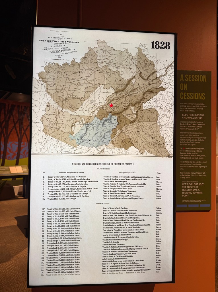
The exhibit (on display through February 14, 2027) is “Lines Were Drawn: The Treaty of Holston and Its Legacy,” and one map stopped me in my tracks. It showed Long Island of the Holston, the Holston River, old treaty lines, and Cherokee land cessions across what became Tennessee. The exhibit is funded by a grant celebrating America’s 250th birthday.
Then I saw the label:
Long Island Fort — 1758
What?
That date immediately caught my eye because Kingsport’s gateway signs say “Settled 1761.” That date did not appear by accident. Historian Hal Spoden advised the city government that Kingsport’s settlement date should be tied to the earliest recognized Anglo-American presence at Long Island of the Holston. That included the Fort Robinson tradition, but it was not only about a fort. It is also connected to the local tradition of Gilbert Christian, who reportedly first came into the Long Island / Reedy Creek area in 1761, later returned, and established Walnut Hill as Kingsport’s first permanent civilian homeplace.
So when I saw “Long Island Fort — 1758” on the museum map, it raised an obvious question.
Was this an earlier fort? Was it an earlier name for Fort Robinson? Was it a temporary military post? Or was it an older map tradition using a different date for the same strategic location?
The more I looked, the more I realized that Long Island was not just one chapter in Kingsport’s history. It was the reference point around which several chapters were written: Cherokee sacred geography, early European exploration, Spanish contact, French river geography, Virginia land speculation, British military strategy, colonial treaty lines, private land purchases, Boone’s Wilderness Road, Revolutionary conflict, federal treaties, and eventually the modern city that grew nearby.
Long before Kingsport was Kingsport, Long Island was already one of the most consequential places in the upper Holston country.
Long Island came first
Long Island was not an ordinary island. It was sacred to the Cherokee. It was a council ground and treaty ground. It stood just east of the junction of the North and South Forks of the Holston River, near one of the major crossings of the Great Indian Warpath, a Native travel corridor through the region. National Historic Landmark documentation describes Long Island as a sacred Cherokee council and treaty ground, surrounded by Cherokee hunting territory, and emphasizes the island’s strategic location near the river junction and the Great Indian Warpath.
That is why Long Island keeps appearing in early maps, treaty descriptions, military accounts, and travel routes. It was not simply scenery. It was a known place, a sacred place, a meeting place, a travel marker, and later a military and legal reference point.
The forts did not make Long Island significant. The treaties did not make Long Island significant. The road to Kentucky did not make Long Island significant.
Long Island was already significant.
Early European exploration was not English
Before Thomas Walker, before Virginia land companies, and long before Daniel Boone’s roadwork from Long Island, European interest in what became Tennessee had already begun.
It was not English at first.
The earliest documented European expeditions into what became Tennessee were Spanish. In 1540, Hernando de Soto’s expedition moved through the interior Southeast. A generation later, Juan Pardo’s 1566–67 expedition moved into the southern Appalachian interior as Spain tried to extend its reach inland from Santa Elena, on present-day Beaufort, South Carolina. Pardo established Fort San Juan at the Native town of Joara, near present-day Morganton, North Carolina, in Burke County. North Carolina’s state history source says Captain Juan Pardo built Fort San Juan at Joara in 1567 and that Native people burned it the next year.
Fort San Juan is not part of Kingsport’s story directly, but it changes the frame. It was an inland Spanish outpost at the foot of the Appalachians, not a coastal settlement. That means the first European push into the southern Appalachian interior was Spanish, not English.
That Spanish layer is no longer just a distant textbook story. Recent archaeology has brought it much closer to Upper East Tennessee. The Cane Notch site, on the middle Nolichucky River in Upper East Tennessee, has produced contact-era evidence, including European trade items and a probable Spanish arquebus lead shot ball. That does not prove Spanish soldiers stood at Long Island of the Holston. It does show that the Spanish-contact world reached into the broader Nolichucky-Watauga-upper Holston region long before the English land-company period.
Salt may also belong in this larger Spanish story, though it should not be overstated. Saltville, Virginia, northwest of present-day Abingdon, was one of the great salt sources of the interior South. Salt drew animals, Native peoples, trade routes, and later European attention. The same salt that later put Kingsport on the map when William King needed a port to transport his salt downriver.
French influence came later, and it followed a different logic: rivers.
To English colonists along the Atlantic seaboard, rivers flowing east belonged more naturally to their coastal world. Rivers flowing west pointed toward the interior — toward the Ohio, the Mississippi, French trade, and French imperial claims. That is why the name French Broad River is so revealing. There was already a Broad River flowing toward the Atlantic. The French Broad, by contrast, flows northwest through the mountains, past the present-day Asheville area, into Tennessee, and joins the Holston at present-day Knoxville to form the Tennessee River. From there, water flows into the Ohio and Mississippi system.
In other words, the name was not random. It reflected a colonial way of reading the landscape. East-flowing waters belonged to the English seaboard imagination. West-flowing waters pointed toward the French interior.
That helps explain the larger world around the Kingsport story. The upper Holston was not isolated. It sat near the divide between Atlantic-facing colonial settlement and interior-flowing river systems tied to Native travel, Cherokee towns, Spanish contact, French influence, and later British-American expansion.
English land companies enter the story
By the time Thomas Walker entered the story in 1750, Europeans had known about the interior South for two centuries. What changed with Walker was not first contact, but English and Virginia land ambition.
Walker explored toward Cumberland Gap, where present-day Tennessee, Virginia, and Kentucky meet, for the Loyal Land Company of Virginia. He was a physician, surveyor, and land agent. Walker should not be treated as a Kingsport founder. I have not seen evidence that Long Island was the focus of his expedition. His importance is more specific: he represents the English land-company phase. Virginia investors were already studying how the Holston country, Cumberland Gap, and Kentucky country connected.
That pressure was building before the boundary lines were settled.
The Virginia names behind the Kingsport story
One of the surprises in this story is how many prominent Virginia figures were connected, directly or indirectly, to the upper Holston and Long Island geography.
These were not minor names.
John Robinson, the namesake of Fort Robinson, was one of the most powerful men in colonial Virginia. Encyclopedia Virginia describes him as Speaker of the House of Burgesses and treasurer of Virginia from 1738 until his death in 1766, and calls him “one of the most powerful political leaders in colonial Virginia.” His death revealed mismanagement of public funds and created a major political crisis in Virginia.
That makes the name Fort Robinson more meaningful. It was not named for a forgotten local figure. It carried the name of the Speaker of the Virginia House of Burgesses and colonial treasurer — a man at the center of Virginia’s political establishment. Robinson was also closely connected to Edmund Pendleton. Pendleton later became one of the executors of Robinson’s estate, and Robinson is often described as Pendleton’s mentor.
Edmund Pendleton is another example of how the Kingsport land story reached back into Virginia’s founding generation. The Virginia Museum of History & Culture describes Pendleton as a Virginia lawyer, judge, and politician who served in the House of Burgesses, attended the First Continental Congress, presided over Virginia’s Revolutionary conventions, became the first Speaker of the Virginia House of Delegates, and later held important judicial roles in Virginia. He is one of those founding-era names many people do not know, but probably should.
That makes the Pendleton tract in present-day Kingsport more than a stray land record. The point is not that Pendleton lived here. The point is that Virginia’s legal and political elite were tied into western land claims before the boundaries were fully settled.
William Byrd III also deserves explanation. He was not simply “Colonel Byrd.” He was the son of William Byrd II of Westover, part of one of colonial Virginia’s great planter families. Encyclopedia Virginia notes that William Byrd III became colonel of the 2nd Virginia Regiment in 1758 and succeeded George Washington as commander of the 1st Virginia Regiment in 1759.
That background helps explain why Byrd’s name appears in the Fort Robinson story. Byrd was not an obscure officer wandering the frontier. He represented Virginia’s military and political establishment during the French and Indian War and Anglo-Cherokee War period. When older sources say “Colonel Byrd” built or ordered a fort near Long Island, that ties present-day Kingsport to the highest levels of Virginia’s colonial frontier policy.
Thomas Walker belongs to the exploration-and-land-company side of that same Virginia world. Walker shows that Virginia investors were already studying mountain routes toward Kentucky before Fort Robinson, before Lochaber, before Henderson’s Transylvania Purchase, and before Boone’s Wilderness Road.
Together, Robinson, Pendleton, Byrd, and Walker tell us something important:
The early Kingsport story was not isolated from the centers of colonial power. Long Island and the upper Holston were connected to the same Virginia network of speakers, judges, governors’ councilors, land companies, surveyors, military officers, and speculators who were trying to understand — and eventually possess — the lands beyond the mountains.
Or more simply:
Robinson gave the fort its establishment name. Byrd brought Virginia military power to Long Island. Pendleton shows the legal-paper trail of elite Virginia land claims. Walker shows the earlier land-company search for a route west. Together, they place present-day Kingsport inside the larger Virginia frontier system.
Why the land story gets confusing
One reason this history is hard to follow is that land was not acquired through one simple process.
At different times, different people claimed the authority to make land deals.
Sometimes land was claimed through private purchases by settlers, speculators, or land companies. Sometimes agreements were made by colonial governments, especially Virginia and North Carolina. Before the American Revolution, some agreements were negotiated under the authority of the British Crown. After the Revolution, treaties were increasingly handled by the United States government.
That means an old line on a map may not tell the whole story. It might reflect a British treaty, a Virginia claim, a North Carolina claim, a private land purchase, a Revolutionary-era agreement, or a later federal treaty. And just because one group recognized a boundary did not mean everyone accepted it.
That is especially true around Kingsport. Long Island sat where several claims overlapped: Cherokee homeland, Spanish contact in the broader region, French interior geography, Virginia ambition, North Carolina jurisdiction, British imperial policy, private speculation, Revolutionary-era settlement, and later United States authority.
So when several lines crowd together around Long Island on the map, that is not a mistake.
It is the story.
Edmund Pendleton and the problem before the Proclamation Line
The Edmund Pendleton land story gives us a concrete Kingsport example of the confusion that already existed before the Royal Proclamation of 1763.
Pendleton was not a backwoods squatter. He was a prominent Virginia lawyer and public figure who later became a major Revolutionary-era leader. Yet local Kingsport sources connect him to a large tract along Reedy Creek and the South Fork Holston, in present-day Kingsport.
The Kingsport Greenbelt marker summary says the Pendleton tract was first surveyed in 1750, covered about 3,000 acres, and extended roughly nine miles from today’s downtown Kingsport upstream toward Holly Springs Church, at Bloomingdale Road and U.S. 11W. It says Virginia granted the tract to Pendleton in 1782, but the land was later determined to fall within North Carolina, so North Carolina recognized the grant and it was recorded in Sullivan County, North Carolina, in 1792.
That chain of dates tells the story almost by itself.
A tract in present-day Kingsport could be surveyed as early as 1750, associated with a Virginia land claim, later granted by Virginia, then eventually recognized by North Carolina because the boundary was not where Virginians thought it was. In other words, the problem was not just Cherokee versus settler. It was also Virginia versus North Carolina, private claim versus public authority, survey versus title, and map versus reality.
Some local histories compress the story into a “1750 grant,” while others refer to later grant or recording dates. That difference is exactly why the Pendleton story is useful. “Survey,” “claim,” “grant,” “recorded,” and “recognized” were not always the same thing.
The Pendleton tract shows that the Kingsport land story was already tangled before 1763. People were not waiting for London, Williamsburg, New Bern, or Cherokee leaders to produce one clean legal map. They were already trying to turn geography into property.
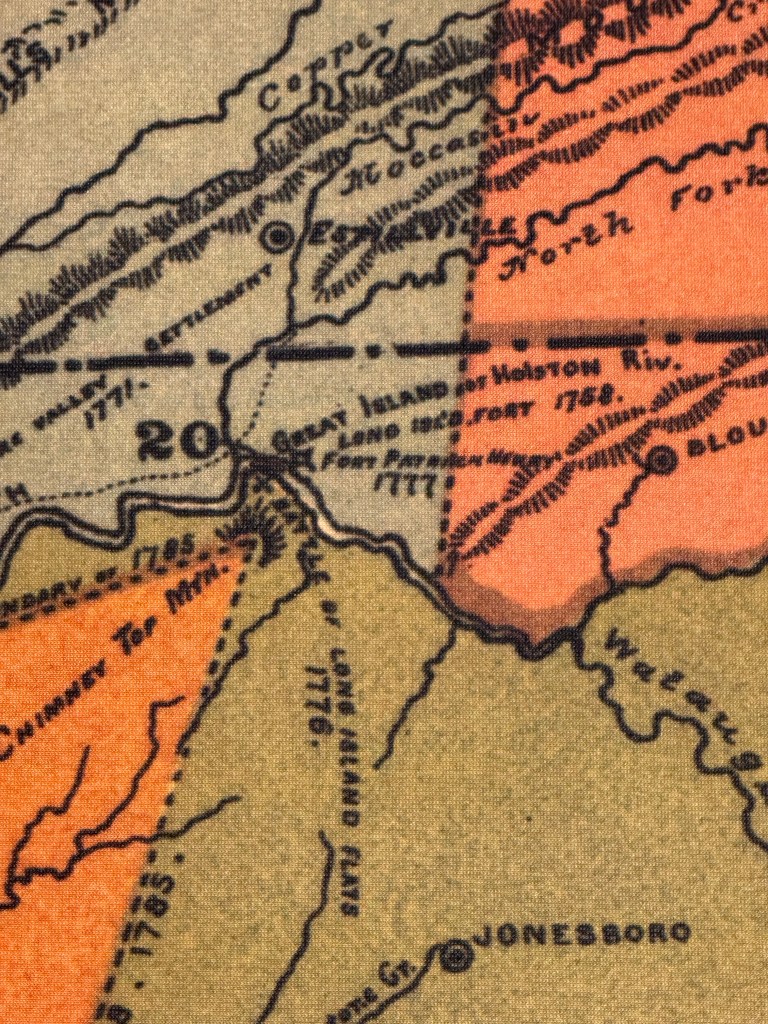
Long Island Fort, 1758 — what was it?
Now back to the reference that caught my attention: Long Island Fort — 1758.
The safest way to handle this is with caution.
Modern summaries usually identify Fort Robinson as the predecessor to Fort Patrick Henry, and date Fort Robinson to the winter of 1760–61, when Colonel William Byrd’s Virginia force was operating in the upper Holston during the Anglo-Cherokee conflict. The Tennessee Encyclopedia identifies Fort Patrick Henry as a Revolutionary War-era fort located on the north side of the South Fork of the Holston near the upper end of Long Island at present-day Kingsport, and says its predecessor was Fort Robinson, built in the winter of 1760–61 by Byrd’s Virginia force.
So what was “Long Island Fort — 1758”?
Older Tennessee histories do refer to a Long Island Fort built in 1758 by Colonel Byrd, or Bird, of Virginia, on the north bank of the Holston opposite the upper end of Long Island. That may be what the museum map was reflecting. But because stronger modern summaries usually use the 1760–61 Fort Robinson date, I would not present “Long Island Fort” as a clearly documented separate third fort unless better primary documentation turns up.
It may have been an earlier fortification. It may have been a temporary military post. It may have been an early descriptive name for the Long Island military location. Or it may be an older historian’s label for the same strategic site later remembered as Fort Robinson.
Even with that caution, the reference is useful. It tells us that the upper Holston was drawing military attention before the settlement boundary was fully settled.
If a Long Island Fort existed in 1758, its purpose was almost certainly military and strategic, not ordinary settlement. This was the French and Indian War era. Britain and France were competing for influence in the interior of North America. British officials wanted to maintain Cherokee alliances, protect trade routes, and keep the French from gaining influence among the Cherokee.
That also explains its relationship to Fort Loudoun, in present-day Monroe County near Vonore, Tennessee. Fort Loudoun stood deeper in the Overhill Cherokee country, along the lower Little Tennessee River. Long Island was different. It guarded the Holston approach. Fort Loudoun projected British power into Cherokee country; Long Island helped secure the route leading there.
A fort did not mean civilian settlement was legal. A military post could exist for defense, trade, diplomacy, transportation, or staging even where ordinary settlement remained restricted or disputed.
If Kingsport was “settled” in 1761, how does that fit the Proclamation Line?
This is where the 1761 date becomes more interesting.
Kingsport’s gateway signs say “Settled 1761.” That date came from the broader Long Island tradition. Hal Spoden’s guidance tied Kingsport’s settlement date to the earliest recognized Anglo-American presence at Long Island of the Holston — military through Fort Robinson and locally through the Gilbert Christian settlement tradition.
That does not mean Kingsport existed as a town in 1761. It means the Long Island area had entered the documented Anglo-American frontier world.
But 1761 was before the Royal Proclamation of 1763.
So how could Kingsport be “settled” before the British Crown prohibited settlement west of the Appalachians?
The answer is that “settled” has to be understood carefully. In the Fort Robinson sense, it meant military occupation. In the Gilbert Christian sense, it reflected early settlement presence or claim, followed by a later permanent return. Neither one meant that private land title was settled, that Cherokee claim had disappeared, or that Kingsport had become a lawful town.
In 1761, Fort Robinson represented British/Virginia military occupation at Long Island. At roughly the same time, local tradition places Gilbert Christian in the Reedy Creek / Long Island area. But Long Island was still Cherokee sacred ground and treaty ground, and the larger upper Holston landscape remained legally contested.
Then came the Royal Proclamation of 1763. After the French and Indian War, the Crown tried to stop or slow settlement west of the Appalachians. In theory, the Proclamation Line was supposed to prevent uncontrolled frontier conflict. In practice, it tried to freeze a frontier already in motion.
People were already moving. Land companies were already interested. Hunters and traders were crossing the mountains. Military posts had already been built. Early settlers were already marking claims and imagining permanence. In places like the upper Holston, Watauga, and Nolichucky, the frontier did not wait for London to clarify the rules.
So the Proclamation Line did not begin the conflict. It exposed the conflict.
From the Crown’s point of view, western settlement was costly and dangerous. From the settlers’ point of view, the land was already being explored, claimed, and in some places occupied. From the Cherokee point of view, these were not empty lands; they were sacred places, hunting grounds, travel corridors, and parts of a larger homeland.
That is why the later treaties were necessary. Hard Labor in 1768 and Lochaber in 1770 were attempts to replace a broad, hard-to-enforce imperial rule with more specific negotiated boundaries. But even those treaty lines struggled to keep up with what was already happening on the ground.
In that sense, Kingsport’s “Settled 1761” sign tells a bigger story than it appears to tell. It does not mean Kingsport began as a lawful town three years before the Proclamation Line. It means Long Island was already so strategic, and the Reedy Creek settlement corridor already so attractive, that Virginia military forces and early settlers were present before the Crown tried to draw a formal boundary. The military post came first. The early settlement tradition came alongside it. The imperial restriction came next. The treaty lines came after that, trying to make legal sense of a frontier that was already moving.
Fort Robinson and Henry Timberlake
By 1761, Long Island had clearly become a military and diplomatic location.
After the Anglo-Cherokee War, Virginia forces under Colonel Adam Stephen were at Fort Robinson, near the upper end of Long Island in present-day Kingsport, close to the Fort Patrick Henry Reservoir / Warriors’ Path State Park area. Cherokee leaders sought peace, and Lieutenant Henry Timberlake volunteered to travel into the Overhill Cherokee towns along the lower Little Tennessee River in present-day Monroe County and surrounding areas.
Timberlake’s journey is one of the most important early connections between present-day Kingsport and written Cherokee history. His party left Long Island in late November 1761, traveled down the Holston, and reached the Overhill towns. His later memoir and map became one of the most important English-language accounts of 18th-century Cherokee towns, diplomacy, and geography.
That gives Long Island another layer of significance. It was not just a defensive site. It was a point of departure for a peace mission.
A simple way to keep the people straight is this:
Spanish expeditions represent the first European-contact layer.
French river geography represents the interior-imperial layer.
Thomas Walker represents the English exploration and land-company layer.
John Robinson represents the colonial Virginia political establishment.
Edmund Pendleton represents elite Virginia legal and land-claim networks.
William Byrd represents Virginia military power on the frontier.
Henry Timberlake represents the military-to-diplomatic layer.
Gilbert Christian represents the permanent civilian settlement layer.
Daniel Boone represents the road-building and settlement-expansion layer.
1763: the Proclamation Line creates a dilemma
After the French and Indian War, the British Crown tried to restrain westward settlement through the Royal Proclamation of 1763. On paper, that sounded orderly. In practice, it created a dilemma.
From the British point of view, western settlement was expensive to defend and dangerous to manage. Every unauthorized cabin, survey, or land claim could lead to conflict with Native nations and force the Crown to respond. British officials were trying to avoid another costly frontier war.
From the settlers’ point of view, the land across the mountains was not an abstraction. Hunters, traders, land speculators, and early settlers were already moving into the upper Holston, Watauga, and Nolichucky country. Some had marked claims, planted crops, built cabins, and started treating the land as home.
From the Cherokee point of view, these were not empty lands waiting to be claimed. They were hunting grounds, travel corridors, town connections, and sacred geography.
That is why the Proclamation Line did not solve the problem. It exposed it.
The Watauga country, around present-day Elizabethton and Carter County, shows the problem clearly. By 1772, settlers in that area were numerous enough to negotiate directly with the Cherokee for a lease. That local reality explains why the later treaty lines became so important. Hard Labor in 1768 and Lochaber in 1770 were attempts to turn an unenforceable imperial rule into more specific negotiated boundaries.
In the Watauga country, settlers were already beyond recognized colonial authority. In the upper Holston around present-day Kingsport, Long Island became central because it was both a known Cherokee landmark and a practical reference point for defining where settlement could and could not go.
The Crown drew a line to stop settlement. Settlers had already begun to cross it. Cherokee leaders were trying to protect their land and sovereignty. Colonial officials were trying to avoid war. Land companies were trying to turn geography into title.
That is the tension behind the map.
1768: the Treaty of Hard Labor
The line marked 1768 on the Royce map refers to the Treaty of Hard Labor, negotiated near Hard Labor, South Carolina, in the western South Carolina backcountry (modern-day Greenwood, SC).
This was a British-era treaty negotiated by John Stuart, British Superintendent of Indian Affairs for the Southern District, with Cherokee leaders. Encyclopedia Virginia describes Hard Labor as a treaty signed on October 14, 1768, confirming the southern segment of a boundary between the British colonies and the Cherokee Nation. It also notes that the two sides continued renegotiating the boundary, shifting it farther west in the 1770 Treaty of Lochaber.
But Hard Labor did not settle the upper Holston question.
It was part of the attempt to replace the Proclamation Line with a clearer Cherokee-colonial boundary. But Virginia land interests were not satisfied, and the line still left uncertainty. The Kingsport area was not yet resolved in the way later maps would show it.
That leads directly to Lochaber.
1770: Lochaber brings the line to Long Island
The Treaty of Lochaber, signed on October 18, 1770, was negotiated at Lochaber Plantation in colonial South Carolina, generally associated with the Ninety Six / western South Carolina region. Lochaber adjusted the Hard Labor boundary. Encyclopedia Virginia’s text of the treaty begins by referencing the earlier Hard Labor agreement and then describes the adjusted line, including a point “six miles east of Long Island” on the Holston.
This is where Kingsport enters the legal geography more directly.
The Lochaber line was described in relation to Long Island of the Holston, in present-day Kingsport. That phrase turns Long Island into more than a sacred place, travel landmark, or military location. It becomes a boundary reference in the formal land system of the British colonial frontier.
The exhibit map makes this visual. The Long Island area is crowded with lines, labels, dates, and cession numbers. Near the island, the map appears to show the 1771 survey point tied back to the Treaty of Lochaber.
1771: Donelson’s survey puts the line on the ground
A treaty could describe a line, but surveyors had to run it through the actual landscape.
That was the purpose of the 1771 Donelson survey. It attempted to translate the Lochaber treaty language into a working boundary. For a modern reader, the “six miles east” point appears to fall generally in the Indian Springs / Island Road / Memorial Boulevard corridor east of Kingsport, though I would not draw the line too precisely without a professional overlay.
In practical terms, the old Lochaber / Donelson geography helps explain why so many historic sites cluster in that broader corridor: Exchange Place, Eaton’s Fort, Yancey’s Tavern, Roller-Pettyjohn Mill, Roller Chapel and Cemetery, and the Barger House area. These places are not random dots. They sit in a corridor shaped by the river, old roads, settlement pressure, and treaty geography.
The Kingsport area was sitting on the edge of a surveyed settlement line.
1772: Virginia keeps pressing west
The treaty list on the museum photo also includes a 1772 treaty with Virginia. I would not make the 1772 treaty the centerpiece of a Kingsport article because the Long Island connection is not as direct as Lochaber or the Path Grant. But it belongs in the background because it shows that Virginia’s western land pressure did not stop in 1770.
The same forces pushing through Southwest Virginia, including the Clinch and Powell valleys and the route toward Cumberland Gap, continued to reshape the region.
The Kingsport story is not isolated. It is part of a larger Virginia-to-Kentucky land corridor.
1775: the Sycamore Shoals transactions were not one simple deal
By 1775, the map becomes even more crowded.
At Sycamore Shoals, in present-day Elizabethton, Carter County, Richard Henderson and the Transylvania Company negotiated a cluster of private land purchases from Cherokee leaders. These are often grouped under the broad label Transylvania Purchase, but that shorthand can hide the geography.
There were several related transactions.
The Great Grant, also known as the Transylvania Purchase, was Henderson’s main objective. It was a massive private purchase intended to create the proprietary Transylvania Colony, mostly in present-day Kentucky. The transaction was controversial from the beginning because it was a private purchase, not a Crown treaty or later United States treaty.
The Path Grant was different. It was the access route. Henderson could not claim land in Kentucky unless settlers could get there. The Path Grant dealt with the corridor from the Holston settlements around present-day Kingsport toward Moccasin Gap near present-day Gate City, Virginia, then through the Clinch and Powell valleys of Southwest Virginia toward Cumberland Gap and the Great Grant lands.
That is why the Path Grant is the most Kingsport-centered of the 1775 transactions. It connected the upper Holston and Long Island geography directly to the route that became Boone’s Wilderness Road.
The same Sycamore Shoals negotiations also included the Watauga / Charles Robertson Grant, dealing with existing settlement around present-day Elizabethton and Carter County, and the Jacob Brown / Nolichucky Grants, dealing with settlement along the Nolichucky River in the area of present-day Greeneville, Erwin, and the middle Nolichucky Valley.
In simple terms:
The Great Grant was the destination.
The Path Grant was the route.
The Watauga Grant addressed existing settlement around Watauga.
The Jacob Brown Grants addressed existing settlement on the Nolichucky.
That is the intuitive way to read 1775.
The Transylvania Company failed as a legal colony. Virginia and North Carolina rejected Henderson’s sweeping claim. But the practical effect was enormous. The private title did not last, but the road did.
Boone and the Wilderness Road
Daniel Boone enters the Kingsport story through the Path Grant and the road to Kentucky.
Boone was hired by Henderson’s company to help open the route into Kentucky. The road did not begin in some vague “frontier.” It began in the Holston settlements around present-day Kingsport. The National Historic Landmark documentation for Long Island states that Daniel Boone, in 1775, began from Long Island to clear the Wilderness Road through Cumberland Gap into Kentucky.
That gives Kingsport a deeper connection to westward expansion than we usually recognize.
Long Island was not just near the route west. It was one of the starting points for the road that helped open Kentucky to large-scale Anglo-American migration. Virginia historic district documentation for Cumberland Gap describes the Wilderness Road as originally blazed by Boone from Long Island of the Holston to Boonesboro, Kentucky, and regional Scott County material similarly describes the route as beginning at Long Island of the Holston at modern Kingsport.
That should be stated honestly. The same road celebrated by settlers was also part of the process that dispossessed the Cherokee. From a geographic standpoint, however, Kingsport sat near the beginning of one of the most important migration corridors in early American history.
1776: Fort Patrick Henry
The next chapter came quickly.
In 1776, Fort Patrick Henry was established on or near the earlier Fort Robinson site. It stood on the north side of the South Fork of the Holston near the upper end of Long Island, in present-day Kingsport, near the modern Fort Patrick Henry Reservoir / Warriors’ Path State Park area. It became a Revolutionary-era military base during conflict with the Cherokee, including attacks associated with Dragging Canoe and the broader Cherokee resistance to colonial expansion.
Once again, the same geography that made Long Island sacred, strategic, and useful for travel also made it valuable in wartime.
1777: Treaty of Long Island / Avery Treaty
In 1777, the Long Island area became a treaty site again.
The Treaty of Long Island of Holston, also known as the Avery Treaty, was held at Fort Patrick Henry near Long Island in present-day Kingsport. North Carolina Digital Collections identifies the surviving proceedings as an account of the treaty with the Cherokee at Fort Patrick Henry near Long Island on the Holston River in June and July 1777.
The Royce map list in the museum photo includes this as the 1777 treaty with Virginia and North Carolina, covering western North Carolina and northeastern Tennessee.
This is one of the reasons the map is so valuable. It shows Long Island not as a one-time reference, but as a repeated point of negotiation. In 1770 it was part of a British colonial boundary. In 1775 it was tied to private land speculation and the road to Kentucky. In 1777 it was the site of a Revolutionary-era treaty.
One important caution: Long Island itself remained a special case. The land around Long Island and the island itself should not be treated as exactly the same thing. Earlier treaties and purchases affected the broader upper Holston region, but Long Island retained a distinct Cherokee status until its final cession in 1806.
1785: Treaty of Hopewell
The line marked 1785 on the map refers to the Treaty of Hopewell, the first federal treaty between the United States and the Cherokee after the Revolution. It was signed at Hopewell, on the Keowee River in present-day South Carolina.
This is a major shift in authority.
Hard Labor and Lochaber were British colonial treaties. The Transylvania Purchase was a private land-company transaction. The 1777 Long Island treaty belonged to the Revolutionary-era world of Virginia and North Carolina. But Hopewell was a United States treaty.
The treaty text describes a boundary using landmarks relevant to this region, including Campbell’s line near Cumberland Gap, Claud’s Creek on the Holston, Chimney-top Mountain near the present-day Fall Branch / Greene County-Washington County area, and Camp Creek near Big Limestone on the Nolichucky in the present-day Limestone / Greene-Washington County area.
That is important for the Kingsport story because it shows the federal government stepping into a situation that was already tangled. The United States did not start with a blank slate. It inherited decades of British treaties, colonial claims, private purchases, disputed settlement, and Cherokee resistance.
Hopewell tried to create a federal boundary, but it did not settle the frontier problem. Too many settlers were already beyond lines that officials tried to draw.
1791: Treaty of Holston
That is why the Treaty of Holston followed in 1791.
The treaty was signed near present-day Knoxville and was part of the new federal government’s attempt to define its relationship with the Cherokee and stabilize the East Tennessee frontier. The treaty text gave the United States the exclusive right to regulate Cherokee trade, guaranteed Cherokee lands not ceded by the treaty, and addressed roads and navigation, including use of a road from the Washington District in East Tennessee to the Mero District around present-day Nashville.
The important point for this article is that the federal treaties did not replace the earlier story. They layered onto it. By 1791, the Long Island / upper Holston region had already been shaped by Cherokee use, British treaties, Virginia claims, North Carolina jurisdiction, private purchases, Revolutionary-era war, and settlement pressure.
1806: Long Island itself is ceded
The final local piece is 1806.
Earlier treaties and purchases affected the land around Long Island. Some private claims may have tried to sweep Long Island into broader transactions. But Long Island itself remained different.
The 1806 treaty cession is especially relevant locally because it involved Long or Great Island in the Holston — the island in present-day Kingsport. The Tennessee Encyclopedia and local historical summaries identify the Dearborn Treaty of 1806 as the final cession of Long Island itself.
That is an important correction to keep in the story. If someone says the Path Grant, the 1777 treaty, or another earlier transaction “gave away Long Island,” I would be careful. The stronger local summary is this:
The land around Long Island moved through several layers of treaty, survey, purchase, and settlement, but Long Island itself remained a special Cherokee place until its final cession in 1806.
A Kingsport way to understand the whole story
Here is the simplest way I now understand it.
Long Island came first.
The Spanish-contact story reminds us that European interest in the interior South did not begin with the English. French river geography reminds us that westward-flowing waters pointed toward the continental interior. Virginia land companies later began studying mountain routes toward Kentucky. Robinson, Byrd, Pendleton, and Walker show that this was connected to Virginia’s political, legal, military, and land-company establishment. Pendleton’s tract shows that paper claims already reached into present-day Kingsport before the Proclamation Line. The forts came because Long Island was strategic. The “Settled 1761” sign reflects military occupation and local settlement memory, not the creation of a lawful town. Gilbert Christian and Walnut Hill give the story its permanent civilian settlement anchor. The treaty lines referenced Long Island because it was widely known. Donelson’s survey used it because treaty language needed to become a real boundary. The Proclamation Line tried to stop settlement, but people were already moving, claiming land, and forcing the issue. The Transylvania Purchase used the same geography because Henderson wanted Kentucky. The Path Grant used the upper Holston because settlers needed a route to Kentucky. Boone’s roadwork began here because Long Island was the logical jumping-off place. Fort Patrick Henry stood here because the same geography that made the place sacred and strategic also made it useful in wartime. The Treaty of Long Island was held here because the place already carried political and symbolic weight. Hopewell and Holston came later because the new United States inherited a boundary problem that had been building for decades.
That changes the way I see Kingsport.
Kingsport is often described as a 20th-century planned industrial city, and that is true. But the deeper story is older and more layered. Before the Model City plan, this was a Cherokee sacred place, a river landmark, a military location, a treaty boundary, a survey reference, a roadhead to Kentucky, and a contested borderland.
The story was not simple. The land was not acquired in one clean transaction. Authority changed over time. Some agreements were Spanish. Some were British. Some were colonial. Some were private. Some were Revolutionary-era. Some were federal. Some were disputed immediately. Some were later superseded. The same place could appear differently depending on which map, treaty, deed, survey, or government was doing the describing.
But that complexity is the story.
The early history of Kingsport is not just a story of forts. It is not just a story of treaties. It is not just a story of roads or rivers. It is the story of a place where all of those forces converged.
Long Island of the Holston helps us read that story.
Before Kingsport became the Model City, it was already a place of consequence.
Clean chronology with modern reference points
Pre-colonial era — Long Island of the Holston, in present-day Kingsport, is a sacred Cherokee place, council ground, treaty ground, and landmark near major travel routes, including the Great Indian Warpath.
1540 — Hernando de Soto’s Spanish expedition enters the interior Southeast, including what became Tennessee.
1566–67 — Juan Pardo’s Spanish expedition moves into the southern Appalachian interior from Santa Elena, on present-day Parris Island, South Carolina. Pardo establishes Fort San Juan at Joara, near present-day Morganton, North Carolina.
Mid-to-late 1500s — Cane Notch, on the middle Nolichucky River in Upper East Tennessee, shows contact-era evidence, including European trade items and a probable Spanish arquebus lead shot ball.
Spanish-era regional context — Saltville, near present-day Saltville, Virginia, was a major salt source in the interior South. It belongs in the regional Spanish-contact background, though the specific documentary connection should be stated cautiously.
French-era geographic context — Westward-flowing waters, including the French Broad River through present-day western North Carolina and Knoxville, pointed toward the continental interior, the Ohio and Mississippi systems, and French influence.
1750 — Thomas Walker explores toward Cumberland Gap, where present-day Tennessee, Virginia, and Kentucky meet, for the Loyal Land Company of Virginia. He is not the first European in Tennessee, but he is one of the earliest well-documented English/Virginia explorers of the Cumberland Gap–Kentucky route.
1750 / 1782 / 1792 — The Edmund Pendleton tract in present-day Kingsport shows the layered nature of land claims: early survey or claim, later Virginia grant, and eventual North Carolina/Sullivan County recognition.
1758 / 1760–61 — Older sources and the museum map refer to “Long Island Fort — 1758.” Modern summaries more firmly identify Fort Robinson as built in the winter of 1760–61 near Long Island by Colonel William Byrd’s Virginia force.
1761 — Gilbert Christian reportedly first settles or attempts settlement in the Long Island / Reedy Creek area of present-day Kingsport, then later returns permanently.
1761–62 — Henry Timberlake travels from Long Island in present-day Kingsport into the Overhill Cherokee towns along the lower Little Tennessee River in present-day Monroe County and surrounding areas, later producing a major early account of Cherokee life and diplomacy.
1763 — The Royal Proclamation attempts to restrain settlement west of the Appalachians, but settlers, land speculators, and early claimants were already pushing into the upper Holston, Watauga, and Nolichucky country.
1768 — Treaty of Hard Labor, negotiated near Hard Labor, South Carolina: British Superintendent John Stuart and Cherokee leaders negotiate a more specific colonial-Cherokee boundary, but it does not settle the upper Holston question.
1770 — Treaty of Lochaber, negotiated in colonial South Carolina: adjusts the Hard Labor boundary and describes the line in relation to a point six miles east of Long Island on the Holston.
1771 — Donelson survey: attempts to run the Lochaber boundary on the ground; the “six miles east of Long Island” point appears generally in the Indian Springs / Island Road / Memorial Boulevard corridor east of Kingsport.
1772 — Treaty with Virginia: part of the continued Virginia westward boundary pressure shown on the Royce treaty schedule. Around the same time, the Watauga settlers near present-day Elizabethton / Carter County were already numerous enough to negotiate a lease directly with the Cherokee.
March 1775 — Sycamore Shoals transactions at present-day Elizabethton, Carter County: Henderson’s Great Grant / Transylvania Purchase, the Path Grant, the Watauga / Charles Robertson Grant, and the Jacob Brown / Nolichucky Grants create overlapping private claims.
1775 — Gilbert Christian establishes Walnut Hill at the mouth of Reedy Creek in present-day Kingsport, later identified locally as Kingsport’s first permanent civilian settlement.
1775 — Boone and the Wilderness Road: Boone’s roadwork connects Long Island and the Holston settlements around present-day Kingsport to Moccasin Gap near present-day Gate City, Virginia, through Southwest Virginia, then to Cumberland Gap and Kentucky.
1776 — Fort Patrick Henry is established on or near the Fort Robinson site at present-day Kingsport, near the Fort Patrick Henry Reservoir / Warriors’ Path State Park area, and becomes a Revolutionary-era military base.
1776 — Col. William Christian, distinct from Gilbert Christian, leads the Revolutionary-era military campaign associated with Fort Patrick Henry and operations against the Cherokee towns.
1777 — Treaty of Long Island of Holston / Avery Treaty: held at Fort Patrick Henry near Long Island in present-day Kingsport with the Cherokee.
1785 — Treaty of Hopewell, signed in present-day South Carolina: first federal treaty between the United States and the Cherokee after the Revolution; includes regional boundary landmarks such as Claud’s Creek on the Holston, Chimney-top Mountain near the Fall Branch area, and Big Limestone on the Nolichucky near the Limestone area.
1791 — Treaty of Holston, signed near present-day Knoxville: the United States attempts to stabilize Cherokee relations and East Tennessee boundaries under federal authority.
1806 — Dearborn Treaty: Long Island itself, in present-day Kingsport, is finally ceded by the Cherokee.

Leave a comment