A friend recently observed that the Holston River just upstream of Kingsport cuts across the ridges, carving a circuitous channel and steep bluffs. You can see exactly what he means as you cross the I-81 bridge and look down at the sheer rock faces dropping into the water. But just a few bends later, the river opens up, and everything changes: thousands of level acres spread out beside a natural, four-mile-long island as the Holston hugs Bays Mountain on its way toward the broad, fertile valleys downstream. The early discoverers called it Long Island and Island Flats—and it was the perfect place to build a fort (Fort Robinson, later renamed Fort Patrick Henry) and launch downstream journeys of discovery on the Tennessee and Cumberland Rivers.
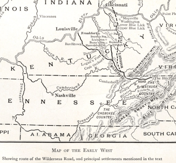
Today I journeyed to Louisville, following the path through Cumberland Gap blazed by Daniel Boone. In the 18th century, it was the main corridor into Kentucky and Middle Tennessee, yet many stretches today are still no more than two-lane roads. Why? Because rivers—not roads—were the great transportation arteries, and trails and paths were built to reach them. As transportation evolved, the river became less important, and commerce was redirected to railroads and interstate highways following different routes that are often many miles from the original.
The quickest way to access the Cumberland River was through the Gap. They even share a name. Somehow, my mind never made that connection, but it makes abundant sense. Today, we may think of the Cumberland River as a series of off-the-beaten-path lakes that aren’t navigable downstream, but that wasn’t always the case.
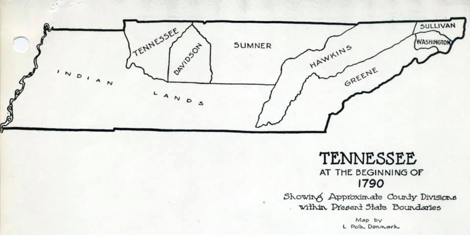
That’s why the earliest maps of Tennessee look so uneven: a few counties in Northeast Tennessee, then a big blank, then a handful of counties in Middle Tennessee near modern Nashville. Everything else was wilderness.
NETWORKS Partnership (i.e., Northeast Tennessee Works), the economic development agency of Sullivan and Hawkins Counties, coined the phrase, “Where Tennessee begins its business day.” I would assert it’s simpler than that: it’s “Where Tennessee begins.”
Many of the same prominent pioneer names from our region—and their predecessors in Virginia and North Carolina—are also prominent in Kentucky and Middle Tennessee. The names remain. We just seem to have lost the connection to time.
For example, the same James Robertson who departed Fort Patrick Henry (Kingsport) on his historic journey of exploration is the same Robertson commemorated by the prominent parkway adjoining the Capitol in Nashville, and the namesake of Robertson County (Springfield).
The same Donelson who negotiated Donelson’s Indian Line near Kingsport is the same Donelson connected to the community on the Cumberland River east of Nashville, adjoining The Hermitage—home of President Andrew Jackson, who married Rachel Donelson.
The same Kilgore family that established Kilgore Station, the historic site in Cross Plains, is my wife’s Kilgore family, who built Kilgore Fort House near Nickelsville, Virginia, and with many descendants who still serve as a political dynasty in Scott County.
The same Preston family who donated land that would become Virginia Tech and owned thousands of acres in the future city of Kingsport is the namesake of Preston Street—the address of the University of Louisville School of Dentistry, where my daughter graduated.
The same Shelby family that founded Shelby’s Station (today’s Bristol) also produced the first governor of Kentucky and gave us Shelby County (Memphis), Shelbyville (home of the Tennessee Walking Horse), and Shelbyville/Shelby County, Kentucky, in the Bluegrass region between Louisville and Lexington.
The same Avery family as Avery County, North Carolina (home of Beech, Sugar, and Grandfather Mountains) connects to the Avery Treaty negotiated at Long Island (Kingsport), and to the Avery Trace—the first road from Southwest Point (Kingston) to Fort William Blount (Gainesboro) on the Cumberland River. In fact, Avery Trace Middle School in Cookeville still bears the name. That road connected the Tennessee River to the Cumberland River, negating the need to go through Cumberland Gap and Kentucky.
The same Gaines family of the Exchange Place historic site in Kingsport echoes in Gainesboro, Tennessee; Gainesville in Georgia, Florida, and Texas; and Fort Gaines guarding Mobile Bay, Alabama.
The earliest mission of roads—really paths—was to get to a river port. The most important towns of the day were crossroads or launching points, just like Kingsport (King’s Port) in the pre-Revolutionary era.
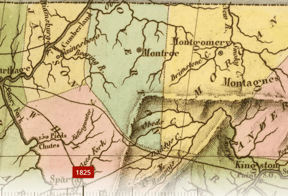
As late as 1825, a map of Tennessee reinforces the point. The most prominent cities in the Upper Cumberland were Williamsburg (on the Cumberland River), Gainesboro (where the Roaring Fork joins the main channel of the Cumberland), and Carthage (where the Caney Fork joins). Important crossroads were county seats Sparta (White County), Montroe/Monroe (Overton County), and Montgomery (Morgan County), the only surviving one being Sparta. Williamsburg, Monroe, and Montgomery—all lost to time—were replaced by Gainesboro, Livingston, and Wartburg.
Then railroads, U.S. 70N, and I-40 arrived. Cookeville, Monterey, and Crossville became the more robust cities we recognize today. In fact, I hardly realized the Cumberland River is even near Cookeville—only about 20 miles away—but what an economic difference 20 miles can make.
But Northeast Tennessee, Southwest Virginia, Eastern Kentucky, North Carolina, and Middle Tennessee aren’t just connected by history. We’re blood kin, too. If you’ve taken a DNA test, you likely have a map showing strong genetic ties passed from generation to generation. I recently saw an old episode of Finding Your Roots where Tim McGraw—whose more recent roots are in Louisiana—traced family back to Rye Cove, Big Stone Gap, and Fort Blackmore, Virginia, just a few miles from Kingsport. His is the story of many.
So next time you’re passing through a place, ask yourself why. Why is this city here?
In 1761, Fort Patrick Henry (Kingsport) was a launching point for westward expansion. It likely would have shared the fate of many early river ports that faded into memory—except it got a second chance a hundred years later, when Northern industrialists decided to “boom a town” here. That gives Kingsport multiple histories: an ancient site sacred to the Indigenous people, followed by European settlement during the colonial era, the Revolutionary era, the antebellum era, and the industrial revolution.
And that’s the point: geography didn’t just shape routes on a map—it shaped who we became. When you see Cumberland Gap, the Cumberland River, Robertson, Donelson, Avery, Shelby, Preston, Kilgore, and Gaines repeating, you’re seeing threads of the same story stitched in different places. These aren’t random names or coincidences; they’re evidence that our region was once a front door, a launching pad, and a connector—of trade, migration, family, and identity. Our region wasn’t a back road—it was a starting place. If we can recover that connection to time, we’ll better understand why some towns rose, why others faded, and why Kingsport keeps showing up at the hinge of something larger than itself.

Leave a comment